Geotechnical engineering services to support the design and construction of the Route 44 over Route 24 interchange in Raynham, MA.
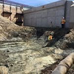
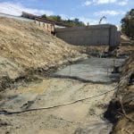
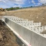
The scope of the design-build procured project included the design and construction of the following elements: full reconstruction with roadway widening, 2-span bridge replacement, two retaining T-walls, four retaining/barrier walls, and several cantilevered overhead guide signs. Nobis coordinated and performed 13 test borings, performed a geotechnical laboratory testing program, and developed the geotechnical recommendations for the bridge foundations, overhead guide cantilever signs, and retaining walls. Geotechnical analyses included bearing resistance, lateral earth pressure, consolidation settlement estimates due to the glaciolacustrine deposit, as well as global slope stability analyses. The analyses were performed in accordance with AASHTO LRFD Bridge Design Specifications and the MassDOT Bridge Design manual. Subgrade preparation observation has been performed during construction to assure that any soft or saturated glaciolacustrine deposits were removed and replaced with compacted structure fill.
challenges
- The portion of the site requiring retaining T-walls was underlain by a glaciolacustrine deposit consisting of silt and clay, which is susceptible to consolidation settlement if additional loads are applied
- The glaciolacustrine deposit has vastly different engineering properties when considering the drained and undrained conditions.
solutions
- Undisturbed soil samples were collected in the test borings, and consolidation and triaxial shear laboratory tests were performed to estimate consolidation behavior as well as the undrained shear value of the glaciolacustrine deposit.
- Advanced 3-D settlement analyses were performed to estimate the long-term settlement due to the roadway widening.
- Detailed settlement monitoring was performed to monitor the settlement of the retaining T-walls during construction, and also to determine if the underlying glaciolacustrine deposit transitioned from an undrained to a drained condition.
results
The results of the settlement monitoring during construction confirmed the estimated settlement obtained in the detailed 3-D settlement analyses during the design phase. These detailed analyses allowed the placement of up to 20 feet of roadway embankment fill over lacustrine deposits without prior ground improvements, thereby reducing the construction cost by over $200,000.