Shoreland protection permit plan for new residence on Lake Winnisquam
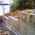
In November of 2024 Richard D. Bartlett & Associates (RDB), a division of Nobis Group, performed a boundary and topographic survey on a one-half acre lot on the shore of Lake Winnisquam in Meredith. The purpose was to create a base plan for a shoreland protection permit plan for a proposed new residential dwelling. Even though it was a considerably small lot, it presented many challenges. The lot was created in the mid-1960s and had a small camp on it that was built on and around exposed ledges, which were abundant throughout the site. The site was very steep and virtually all boundary evidence was destroyed or disturbed, which prompted surveying portions of the abutting lots to recreate the original subdivision. Location of site details involved all impervious surfaces, all trees within 50 feet of the lake reference line, and complete topographic survey. Boundary calculations also involved determining the limit of public ownership along the lake and re-establishing lot lines. A subsequent field survey consisted of a preliminary building layout for the purposes of blasting ledge; an additional layout for construction of the foundation; and a follow up survey to certify that the foundation did not encroach on building setbacks or the shoreline waterfront buffer.